It was exactly 9:00am when I stood on the harbour ramp at Whitehaven for the start-of-ride photograph. The air was humid and the temperature was
already just over 20 C.
 |
| Whitehaven Harbour |
I set my MP3
player to random and switched it on before pedalling away to the sound of ‘Thank
God it’s not Christmas’ by Sparks.
It took me just a mile and a half until the first time I rode past a turning, due to two sodding great people-carriers that had been parked
on double-yellow lines, completely obscuring the entrance to the off-road cycle
route.
The next couple of miles were a on succession of footpaths through
grassy fields and council estates where a third of the houses appeared to have
been painted in exactly the same shade of magnolia. I assume somebody got hold of a job lot. In several places the
paths were strewn with broken Budweiser bottles. I passed a couple of people
with bikes upside-down, attending to punctures. I offered to help but was
relieved when both declined.
For a few miles I could see that the path was always sloping
upwards but the gradient was gentle and my legs were fresh so it really didn’t
feel like I was climbing. Trees were growing at either side of the grass verges, containing the view.
 | ||
| Weird industrial structures abound. This was actually a seat. |
Suddenly the trees stopped and the view opened out, giving me my first look at the hills in the distance.


After about ten miles of off-road, but generally well-surfaced tracks, the route fed out onto roads. I was happily amazed when after ten minutes, I still hadn't seen another vehicle. There was quite a climb just outside Kirkland and suddenly the hills seemed an awful lot closer.
 |
| Ironically, Thomas Dolby's "The Flat Earth" was on my MP3 player here. |
So far it had all been uphill, but now came the first of many cyclist warning signs...

...which is just as well because in addition to the bends and gradients, shortly after this sign the road had been resurfaced and was covered in a layer of very small and exceptionally loose chippings.

After a few more easy-ish climbs, it was all downhill to Loweswater where I stopped off for a few minutes to soak my cap in the icy water. It was overcast but felt much hotter than the 23 C showing on my Garmin.
 |
| Loweswater. |
The climb out of Loweswater was rewarded by some cracking scenery...


The next five miles or so were brilliant, like being on a roller-coaster. Descents were followed by uphill bits but, because of the momentum I'd gathered, I hardly had to pedal to reach the top, before plunging down the next drop.
That all ended at High Lorton, where a short but really steep incline had me in bottom gear and gasping for breath. This was followed almost immediately by the climb up the Whinlatter Pass. This wasn't actually as bad as I'd expected, and a long steady spin in low gear got me to the top. It was, however, getting very hot, with my Garmin now reading 27 C, so I took a detour to the Siskins Cafe in the Whinlatter Visitor Centre.
 |
| Top of the Whinlatter Pass |

I don't recall a great deal about the ride from the top of Whinlatter into Keswick, so it couldn't have hurt that much. There were some lovely views...

And a suspension footbridge just outside Derwent Water...

...and then I was in Keswick. After a glorious morning of splendid isolation it was odd to suddenly see so much traffic and people again. I would have ridden straight through but I needed to top up my water bottles, as the Garmin was now registering 32 C and the sun was beating down.
 |
| Keswick. Way too busy for my liking |
I pushed the bike into a general store and emerged with a couple of bottles of Gatorade and a rum and raisin ice cream cone. With hindsight I should have eaten the ice cream and then refilled my water bottles. That way I wouldn't have dropped the ice cream onto the concrete while trying to lift a bottle out of the cage. I had an urgent desire for cooling down and for calories so, much to the delight of a little girl looking on, I picked up the ice cream, prodded it back in the cone with a grubby finger and ate it while it melted over the back of my glove.
It's about two miles from the centre of Keswick to the Castlerigg stone circle, and both of those miles are very much uphill in nature. I'd visited the circle once before, on a cold bleak day in March, and had the place to myself. On that day I was impressed by how it imposed a presence on the landscape. Today it just seemed like a field with rocks in, swarming with people, picnicking and taking pictures of each other in front of the stones. I waited till I had got my breath back and left them to it.
 |
| View from Castlerigg, avoiding the tourists and ice cream vans. |
The next few miles were mainly downhill, easy going and pleasantly scenic..

Until now the navigation track I had plotted into my Garmin had been spot on. The route is generally really well sign-posted anyway, but I found it nice to be given a few hundred yards warning before any turn.
Now it tried to take me up onto the Old Coach Road, through a big gate and a sign declaring it to be unsuitable for motor vehicles. I looked at the rough surface of packed rock, then looked at my flimsy road-wheels, and thought 'stuff that for a lark'.
I'd checked this bit of the route against the Google Earth satellite images when planning the ride and it had looked OK, but I really didn't want to risk it so I turned back and then followed the first signpost I saw that pointed towards Penrith.
This took me on a five mile stretch of the A66 which, compared to even the minor roads in Kent, was virtually traffic-free. It was a long steady slog and the Garmin was hovering around 31 C. I was a bit concerned to see a sign indicating there would be a slow-vehicle crawler-lane for two of those miles, but it didn't appear to get much steeper than it had been previously.
The heat was really uncomfortable and I stopped for a couple of minutes at the top for a drink, and to take my shoes off for a few minutes. It surprised me how much they'd swollen over the day.
Once I'd turned off the A66 I was treated to another succession of roller-coaster drops and climbs, with very little effort required. I rejoined my originally-planned route just outside Greystoke, where I came across a really nice cycle cafe. Although I knew I didn't have far to go to Penrith, I couldn't resist sitting in the sun with a big mug of tea and a huge slab of lemon drizzle cake. My Garmin was up to 37 C in the sun and it felt ridiculously hot.

 |
| Greystoke Castle, viewed from the cafe garden |
Just five more miles and a couple of small hills ( at one of which, in Newton Reigny, I managed to trigger a speed warning sign - I was doing 8mph) later I rode into Penrith, my first overnight stop.
I think I spent about 30 minutes cooling down in the shower. I'm so glad I took the B&B option - with an overnight low of 20 C forecast, it would have been unbearable in a tent.
 |
| The finance sector of Penrith. Everywhere you look there is a bank. |
I had a couple of pints in the local Wetherspoons and then, as tomorrow would be Canada Day, I treated myself to a large helping of Poutine, the Canadian national dish from the Angel Lane chippy.
Although, being Cumbria, in order to get it I had to ask for "cheesy chips wi' gravy".
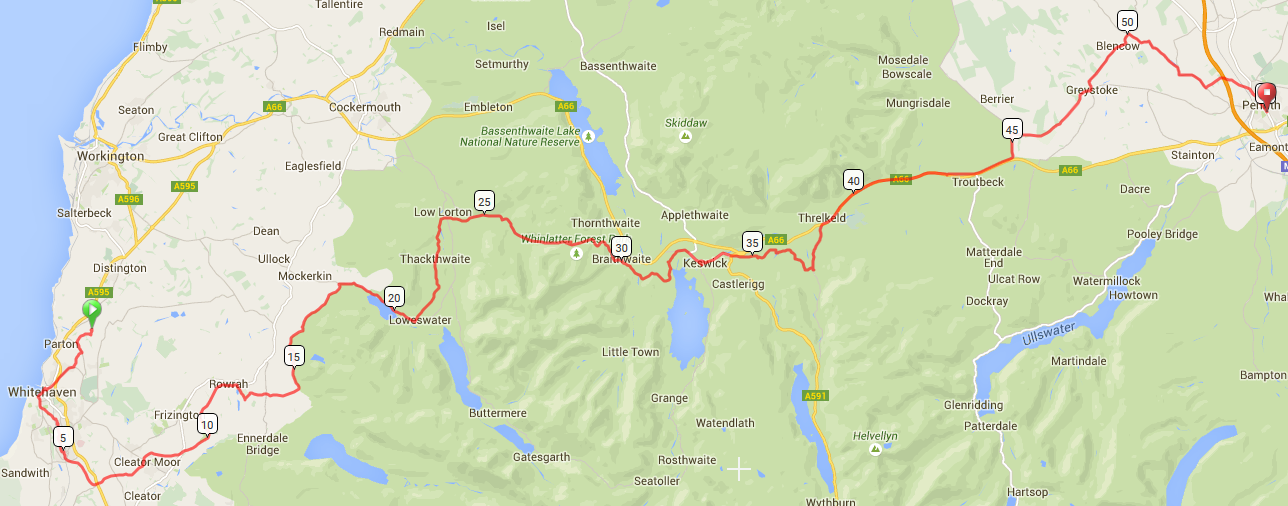
The Route:
No comments:
Post a Comment
Note: only a member of this blog may post a comment.